Contents12 sections
This guide was first published in German on handgetestet.de.
Before you think about display sizes, settle one question: do you hike where your phone still has coverage? If so, a solid navigator with a topo map is enough, and the Garmin eTrex Touch is a sensible choice for typical tours in low mountain ranges and the Alpine foothills. If you regularly head into dead zones, on the other hand, you need satellite communication with SOS, either built in as on the GPSMAP 67i or as a small add-on device.
Many people buy it the other way around. First the nice navigator, and only later, on a ridge without reception, do they realize that it knows the way but cannot reach anyone.
Navigator, satellite messenger or both?
A handheld GPS receives satellite signals to determine your position. That does not mean it can transmit. Messages and emergency calls without cell service run over a dedicated satellite network, which is Iridium for both Garmin inReach and Zoleo. Without an active plan, the SOS button stays silent; Garmin and Zoleo state this explicitly.
On top of that, you need a clear view of the sky. Zoleo points out that the emergency call depends on satellite contact, and in a narrow gorge or under dense forest that can take a while. None of the providers guarantees a rescue. Zoleo itself states that it is not a licensed rescue service; the emergency call goes to its partner Global Rescue, which alerts the responsible authorities. With Garmin, an SOS reaches Garmin Response, a coordination center staffed around the clock.
What really matters on the spec sheet
- Map: Garmin ships the eTrex Touch, GPSMAP 67i and GPSMAP H1i Plus with TopoActive maps, meaning trails, contour lines and elevation data. More detail, such as satellite imagery and protected-area boundaries, is available through Outdoor Maps+, which is purchased separately.
- Battery: Built-in battery or AA batteries? The eTrex SE runs on two AA cells, which you can simply buy along the way on a hut tour. The other Garmin navigators charge by cable; a power bank in your pack is then a must.
- Multi-band: Reception on two frequencies helps between rock faces and in narrow valleys. According to Garmin, the eTrex Touch, GPSMAP 67i and H1i Plus support it.
- Controls: Touchscreens are finicky in the rain and with gloves. That is why the H1i Plus also has buttons, and the GPSMAP 67i relies on buttons.
A word on battery life. Manufacturer figures apply to specific modes, often with infrequent tracking or the screen switched off. For the inReach Mini 3 Plus, Garmin quotes 350 hours in power-saving mode, but only 95 if the device is constantly listening for messages.
Seven devices for hikers compared
| Model | Map and display | Battery life according to manufacturer | Satellite and SOS | Best for |
|---|---|---|---|---|
| Garmin eTrex Touch | 3-inch touch, TopoActive | up to 130 h (multi-band), 650 h expedition | no | hikers with coverage |
| Garmin eTrex SE | 2.2 inches, no topo map | up to 168 h with 2 AA | no | beginners, following tracks |
| Garmin GPSMAP 67i | 3 inches, buttons, TopoActive | up to 180 h GPS, 165 h with inReach | yes, Iridium, subscription required | Alpine terrain, Scandinavia, solo trips |
| Garmin GPSMAP H1i Plus | 3.5-inch touch plus buttons | up to 145 h | yes, also voice and photo | expeditions, group leaders |
| Garmin inReach Mini 3 Plus | small color display, map via app | up to 350 h power-saving mode | yes, text, voice, photo | add-on to phone or navigator |
| Zoleo | no display, phone app only | over 200 h | yes, SOS button on the device | affordable entry into satellite messaging |
| TwoNav Cross Plus | 3.2-inch touch, 172 g | about 20 h | no (SeeMe only via phone) | hiking and mountain biking |
Garmin eTrex Touch
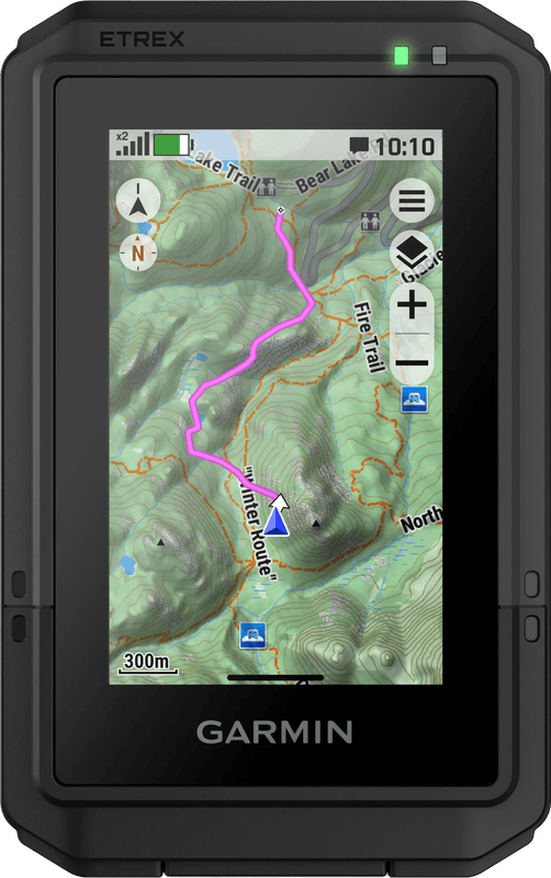
The eTrex Touch arrived in fall 2025 with a 3-inch touchscreen, multi-band reception and a preloaded TopoActive map. Garmin quotes up to 130 hours of battery life with all satellite systems and up to 650 in expedition mode, plus IP67 protection and shock resistance to MIL-STD-810. For day hikes and hut-to-hut tours in the Alps, we consider that enough device. It has no satellite messaging.
Garmin eTrex SE
Small, rugged, economical. According to the manual, the eTrex SE runs for up to 168 hours on two AA cells, and up to 1,800 in expedition mode. The 2.2-inch display shows your position, the distance covered and waypoints as lines; do not expect a hiking map with contour lines. For a firmly planned route, that is enough. If you want to look for alternatives on the map while out on the trail, you will be frustrated.
Garmin GPSMAP 67i
Here everything comes in one housing: a 3-inch display, button controls, a 3-axis compass, a barometric altimeter, TopoActive maps and an inReach module for messages, tracking and SOS via Iridium. According to the manual, the battery lasts up to 165 hours with inReach and 10-minute tracking, and up to 180 without satellite messaging. One limitation in water resistance: Garmin specifies IPX7, meaning half an hour at a depth of one meter. If you travel alone in remote areas and only want to carry one device, this is the obvious candidate.
Garmin GPSMAP H1i Plus
Garmin’s premium handheld from 2025 has a 3.5-inch touchscreen with additional buttons, a camera and a flashlight that doubles as a signal light, plus a siren. Via inReach Plus, it sends texts, voice messages and photos, even during an SOS. Garmin quotes up to 145 hours of battery life in multi-band mode. For hikers who mostly stick to marked trails, that is too much technology. It gets interesting for people who lead groups or spend weeks off the beaten track.
Garmin inReach Mini 3 Plus
A satellite communicator, not a navigator. It has a color touchscreen, a speaker and a microphone, and sends texts of up to 1,600 characters and voice messages up to 30 seconds long. Navigation runs through the Garmin Explore app on your phone, including the route back to the start. According to the manual, the battery lasts up to 350 hours in power-saving mode with 10-minute tracking, and up to 95 in the mode with constant message reception. It makes sense if you already have a navigator or a phone with offline maps and only the emergency channel is missing.
Zoleo
Zoleo does without a display. You write texts in the app on the paired phone, and the device sends them via Iridium, cellular or Wi-Fi. The SOS button under a protective cap and a check-in button also work without the phone, for example when its battery is dead. Zoleo quotes 150 grams, IP68 to 1.5 meters for 30 minutes and more than 200 hours of battery life. The smallest plan costs in the low double digits of euros per month, plus a one-time activation fee and a minimum term of three months. After that, the account can be paused for a small monthly fee.
TwoNav Cross Plus
The compact TwoNav device weighs 172 grams and has a 3.2-inch touchscreen, a barometer, a digital compass, IP67 and, according to TwoNav, about 20 hours of battery life. That is considerably less than the Garmin navigators. The SeeMe emergency function requires a paired smartphone with an internet connection, so it is no help in a dead zone. If you also do a lot of mountain biking alongside hiking and use the handlebar mount, this is an alternative; pure cyclists are better off with our guide to bike computers with navigation (in German).
How we would decide
- Marked trails, coverage most of the time, tours of up to a week: Garmin eTrex Touch.
- Small budget, route fixed in advance: Garmin eTrex SE, with spare batteries in the lid pocket.
- Alone in the Alps, in Scandinavia or on long-distance trails without coverage: Garmin GPSMAP 67i, because the navigator and the emergency device do not need to be charged separately.
- You already have a navigator or phone and only the emergency call is missing: inReach Mini 3 Plus or Zoleo, depending on whether you need voice messages and a display of its own.
With all satellite devices, factor in the subscription costs over several years. Garmin offers four plan tiers, from the basic plan with SOS up to Premium. Before buying, check whether and under what conditions the service can be paused if you only spend two weeks in the mountains in summer. And pack the device where you can reach it in an emergency: on the shoulder strap of your hiking backpack, not in the bottom compartment.
Frequently asked questions
Can a GPS device send an emergency call?
Only with its own satellite communication. A handheld GPS receives signals to determine your position, so it cannot transmit. Messages and emergency calls without cell service run over Iridium with Garmin inReach and Zoleo. Without an active plan, the SOS button stays silent; both manufacturers state this explicitly.
Which GPS device for hiking in the Alps?
For day hikes and hut-to-hut tours with coverage, the eTrex Touch: 3-inch touchscreen, multi-band reception and TopoActive map. If you travel alone in remote areas and only want to carry one device, the GPSMAP 67i is the obvious candidate, because the navigator and the emergency device do not need to be charged separately.
AA batteries or rechargeable battery in a GPS device?
The eTrex SE runs for up to 168 hours on two AA cells, and you can simply buy replacements along a hut tour. The other Garmin navigators charge by cable, so a power bank in your pack is a must. Manufacturer battery life figures often apply to economical modes with infrequent tracking.
Is an inReach Mini or Zoleo worth it in addition to a phone?
Yes, if you already have a navigator or a phone with offline maps and only the emergency channel is missing. The inReach Mini 3 Plus has a display, text and voice messages. Zoleo does without a display, but its SOS and check-in buttons also work without a phone. Factor in subscription costs over several years.
Does a satellite SOS guarantee rescue?
No. The emergency call depends on a clear view of the sky; in a narrow gorge or under dense forest, it can take a while. Zoleo itself states that it is not a licensed rescue service; the call goes to Global Rescue. With Garmin, an SOS reaches Garmin Response, a center staffed around the clock.
Sources
- Garmin: eTrex Touch, announcement
- Garmin: eTrex Touch, specifications
- Garmin: eTrex SE/Solar owner’s manual (PDF, German)
- Garmin: GPSMAP 67 and eTrex SE, announcement
- Garmin: GPSMAP 67i, specifications
- Garmin: GPSMAP H1i Plus, announcement
- Garmin: GPSMAP H1/H1i Plus, specifications
- Garmin: inReach Mini 3 Plus, announcement
- Garmin: inReach Mini 3/3 Plus, battery life
- Garmin: overview of inReach subscription plans
- Zoleo: satellite communicator, specifications
- Zoleo: how the SOS emergency call works
- Zoleo: plans
- TwoNav: Cross Plus
Where to buy
- Garmin eTrex TouchCheck price at Amazon.deAvailable in Germany: Amazon.deView at CoolblueAvailable in Germany: Coolblue
- Garmin eTrex SECheck price at Amazon.deAvailable in Germany: Amazon.deView at CoolblueAvailable in Germany: Coolblue
- Garmin GPSMAP 67iCheck price at Amazon.deAvailable in Germany: Amazon.de
- Garmin GPSMAP H1i PlusCheck price at Amazon.deAvailable in Germany: Amazon.de
- Garmin inReach Mini 3 PlusCheck price at Amazon.deAvailable in Germany: Amazon.de
- Zoleo SatellitenkommunikatorCheck price at Amazon.deAvailable in Germany: Amazon.de
- TwoNav Cross PlusCheck price at Amazon.deAvailable in Germany: Amazon.de